
Morocco Map– A Detailed Map of the Country of Morocco
Morocco officially referred to as the Kingdom of Morocco is a country located in North Africa with a population of nearly 34 million. Morocco has a coast on the Atlantic Ocean that reaches past the Strait of Gibraltar into the Mediterranean Sea. Morocco is a country in North Africa with a population of over 34 million. The Kingdom of Morocco is a country located in North Africa on the Atlantic and Mediterranean coasts sharing international borders with Algeria, Mauritania, and Spain via the Strait of Gibraltar and the Spanish autonomous cities of Ceuta and Meilliain. Morocco is a country full of exotic locales and wondrous treasures for travelers who desire to see North Africa and explore a moderate Muslim country with a welcoming culture, a wide array of natural beauty, and a vast wealth of history. Few countries match the Destination of Morocco. With its iconic monuments, UNESCO Heritage Sites, Majestic Gardens High Atlas Mountains, Coastal regions and the grand Sahara Desert.
For more information and to view a Morocco Map
Morocco Geography & Morocco Topography:
Morocco is well situated on the far northwestern corner of Africa and has an expansive shoreline that stretches from the Atlantic Ocean to the Strait of Gibraltar. The majority of the Moroccan coastline borders the Atlantic Ocean with the tip of the country in the Tangier – Tetouan region (near Spain) down to the Eastern border of Algeria, bordering the Mediterranean Ocean. The topography of Morocco is varied. Morocco has one of the most extensive systems of rivers in North Africa.
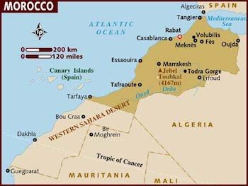
Travelers to Morocco can expect to discover a wide variety of scenery as the country has mountainous interiors in the North (Chefchoueun, Tangier, Tetouan) extremely fertile agricultural regions (Coast area of Agadir, Souss Valley and Fes) to an arid and dry climate inland towards the Sahara Desert region (Draa Valley Region, Zagora, Merzouga and Erg Chegaga) and green Valleys (Dades & Todra).
Morocco Map FAQ:
Kingdom of Morocco: (Al Mamlaka al-Maghrebiya)
Capital of the country: Rabat
Largest city: Casablanca
Language: Arabic (official), Berber dialects, French often the language of business, government and diplomacy
Literacy:Total Population: [52%] Male: [66%]; Female: [44%]
Religion: Muslim
Government: Constitutional Monarchy
Chief of State: King Mohammed VI
Area: 446,550 km² (56th biggest country in the world)
Population: 36 million
Area:172,413 square miles; slightly larger than California
GDP: $4,600
Year of Independence: 1956
Currency: Dirham (MAD;DH) 100 Dirhams about 10 Euros / $13 US
Notes: DH 10, 20, 50, 100 & 200.
Coins: DH 1, 5 & 10/5, 10, 20 & 50 centimes
Calling code: +212
Local Time in Morocco: Greenwich Mean Time
Weights & Measures System in Morocco: Metric
Population Density: 72 People per square kilometer
Age of Population:
0-14yrs Males: 5,355,388; Females: 5,156,762